




Before the trails, pools, established neighborhoods and Great Oaks Drive, this part of Williamson County looked very different.
Drive through Brushy Creek today and one of the first things you may notice is that it doesn't feel like a community that appeared all at once.
Some streets have homes dating back decades.
Others have a completely different architectural style.
There are mature trees that tower over houses, pocket parks tucked between residential streets, trails that seem to disappear into the woods and neighborhoods that don't all follow the same layout.
That's because they don't share the same development story.
Brushy Creek wasn't built in one phase by one developer.
It grew in layers.
And to understand why it feels different from many recently developed Central Texas suburbs, you have to go all the way back to the creek itself.
First: The Creek Is Much Older Than the Community
Brushy Creek isn't simply the name developers chose for a subdivision.
It's an actual Central Texas waterway stretching roughly 69 miles through Williamson and Milam counties before reaching the San Gabriel River. The Handbook of Texas notes that Spanish explorers recorded the creek as early as 1716, calling it Arroyo de las Ánimas Benditas—Creek of the Blessed Souls.
The wooded banks and water source later made the Brushy Creek corridor an important part of early settlement in Williamson County.
By the 1830s, land along Brushy Creek was being claimed through early Texas land grants, and settlement expanded throughout the creek corridor. Williamson County's historical research identifies multiple historic headright tracts within what eventually became today's Brushy Creek community.
So while we tend to think about Brushy Creek today in terms of Cat Hollow, Great Oaks or trails...
people were navigating, farming and settling along this creek long before there were subdivision signs.
A Fun Piece of Local History: Round Rock Was Originally Called Brushy Creek
Yep.
Before there was a Round Rock, there was Brushy Creek.
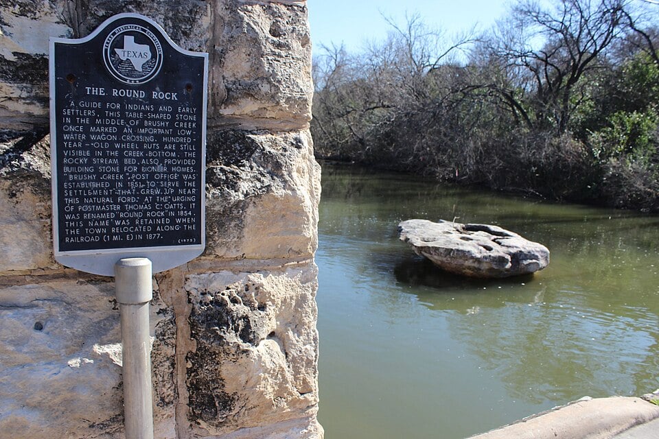
A settlement near the creek crossing east of today's Brushy Creek community was established under the name Brushy Creek in 1851. The name was changed to Round Rock in 1854, inspired by the distinctive table-shaped limestone rock that marked a low-water crossing in the creek.
That historic settlement is not the same thing as today's Brushy Creek CDP—but it shows just how deeply the creek itself is tied to the identity of western Round Rock and Williamson County.
Historical Brushy Creek

The first historic image above comes from The Williamson Museum through the Portal to Texas History and shows a railroad bridge over Brushy Creek in Old Town Round Rock. The second shows flood damage along Brushy Creek in Williamson County in 1958.
I would use these primarily as historical references and check the Portal's individual usage guidance before republishing them commercially.
From Ranches & Limestone to Residential Streets
Now we fast-forward more than a century.
The Brushy Creek community we recognize today started taking shape in the mid-1970s.
And here's one of my favorite facts from the research:
Before much of this area became residential, the land had primarily been used for ranching and limestone quarrying.
That makes sense when you drive through the area today.
The natural limestone.
The rolling terrain.
The creek beds.
The established oak trees.
Modern Brushy Creek wasn't dropped onto a blank piece of prairie. Residential development worked its way across land that already had a physical character of its own.
The First Brushy Creek Neighborhoods Arrived in the 1970s
This is where the timeline gets really interesting.
Williamson County's historical research identifies several of the earliest residential areas on the north side of Brushy Creek:
Spanish Oak Terrace — first developed around 1973–74
Great Oaks — first developed around 1973–75
Tonkawa Springs — first developed around 1977
Brushy Creek North followed during this same early period. District engineering records show Brushy Creek North Sections 1 and 2 were platted in 1977, with much of the utility infrastructure installed during the early 1980s.
That means portions of Brushy Creek were already taking shape before many of the suburban communities people associate with today's Austin metro even existed.
And this begins to explain those mature trees and less uniform streets.
They've had decades to evolve.
Then Came the MUD
To understand modern Brushy Creek, you really have to understand the Brushy Creek Municipal Utility District.
And no, a MUD isn't just the thing listed on a tax bill.
A Texas Municipal Utility District is a special governmental district that can provide services such as water, wastewater, drainage, parks and recreation.
Brushy Creek's district was originally created as:
Williamson County Municipal Utility District No. 2
on October 27, 1977.
A confirmation election followed on January 21, 1978.
At the beginning, the district covered approximately 725 acres.
Think about that.
The residential neighborhoods were beginning to form...
and almost simultaneously, the infrastructure organization that would eventually help tie many of those neighborhoods together was being created.
Brushy Creek Got Much Bigger in 1983
The original MUD was relatively small.
Then came a major expansion.
In 1983, the district annexed much of the land south of Brushy Creek that is now part of the community.
That increased its size from roughly 725 acres to 2,210 acres.
Suddenly the framework existed for substantially more residential development.
And the 1980s delivered exactly that.
The 1980s Changed Brushy Creek
Several of the neighborhoods buyers recognize today appeared during this era.
According to Williamson County:
Woods of Brushy Creek — first developed in 1985
Fern Bluff — first developed around 1986–87
Cat Hollow at Brushy Creek — first developed in 1987
Later, Stone Canyon began developing around 1995–96.
And this staggered timeline is important.
Brushy Creek wasn't one subdivision built from entrance monument to final cul-de-sac in five years.
You had development occurring in the 1970s.
Then the 1980s.
Then the 1990s.
And further expansion afterward.
Wait...It Wasn't Even Called Brushy Creek MUD Yet
Here's another fun one.
Although the district was created in 1977, it remained officially named Williamson County Municipal Utility District No. 2 for more than a decade.
It wasn't renamed Brushy Creek Municipal Utility District until August 31, 1990.
By then, the community itself had clearly developed its own identity.
Brushy Creek Was Growing FAST
The population numbers tell the story.
In 1990, Brushy Creek had approximately 5,833 residents.
By 2000?
Approximately 15,371.
That's nearly triple the population in only a decade.
The 2020 Census counted approximately 20,953 residents, making Brushy Creek the largest Census Designated Place in Williamson County at that time.
That's quite a transformation from ranch land and limestone quarries.
But Brushy Creek Never Became a City
This is one of the most interesting parts of the story.
Brushy Creek today is a Census Designated Place—or CDP.
That means it's recognized by the Census Bureau as a concentration of population...
…but it is not an incorporated city.
Williamson County describes it as a loosely connected collection of subdivisions served by a central community center, neighborhood associations and businesses around the edges.
And that description might be the key to understanding Brushy Creek.
It isn't one neighborhood.
It isn't one subdivision.
And it isn't a city.
It is a collection of communities that gradually became connected through roads, utilities, parks, schools, trails and shared amenities.
For a While, Parts of Brushy Creek Were Even in Different City ETJs
Here's how unusual the development story gets.
For roughly the first 20 years of the MUD's existence, portions of the district sat within the extraterritorial jurisdictions of both Austin and Round Rock.
In 1997, the Brushy Creek MUD Board elected to move all district land into Round Rock's ETJ.
Again, Brushy Creek wasn't following the standard trajectory of:
Developer buys land → city annexes → subdivision appears.
Its structure evolved over time.
The MUD Became Much More Than Water & Sewer
This is the piece I think explains modern Brushy Creek better than almost anything else.
As the community grew, the MUD gradually became responsible for much more than utility infrastructure.
Parks and recreation expanded dramatically.
Brushy Creek MUD says part of that expansion was funded through developer fees paid as residential lots were sold.
Over time, the district developed and maintained places including:
Brushy Creek North Park
Cat Hollow Park
Creekside Park
Shirley McDonald Park
Pepper Rock Park
Racine Woods Park
Little Village Park
Sendero Springs Park
Highland Horizon Park
Sendero Valley Park
Community Park
along with greenbelts, trails, four pools and other recreation facilities.
That's an important reason parks feel so woven into the residential areas.
They didn't all arrive as one giant amenity package at the entrance of a master-planned community.
They developed alongside different parts of Brushy Creek.
Then Came the Brushy Creek Community Center
In 2004, the Brushy Creek Community Center opened with approximately 35,000 square feet.
It was later expanded and renovated in 2017, growing to more than 60,000 square feet.
Today, the Community Center and surrounding park on Great Oaks Drive function almost like a geographic and recreational heart of Brushy Creek.
And that's particularly interesting when you remember:
there is no Brushy Creek City Hall.
The Community Center fills a different role, but it has become one of the places that helps give a collection of subdivisions a shared identity.
Brushy Creek Kept Expanding
Development didn't stop with Cat Hollow or Woods of Brushy Creek.
Later communities added more layers, including areas such as:
Sendero Springs
Highland Horizon
Liberty Village/Neenah Oaks
Meadows of Brushy Creek
Villages of Brushy Creek
and additional sections within Woods of Brushy Creek.
Brushy Creek MUD now covers approximately 2,300 acres in two non-contiguous areas and serves numerous distinct HOAs rather than a single subdivision association.
Sendero Springs and Highland Horizon provide a particularly good example of this later development. In 2001, the developer of those projects petitioned the district to establish a defined area to finance infrastructure, and voters approved it in 2002.
So even decades after the first Great Oaks streets appeared, Brushy Creek was still adding another chapter.
The Creek Eventually Became an Amenity Again
There's a beautiful full-circle moment in all of this.
The creek that originally influenced settlement...
then ranching...
then roads and subdivisions...
eventually became one of the area's largest recreational features.
The Brushy Creek Regional Trail now runs directly through the community.
Williamson County describes the mostly concrete trail as approximately 7.75 miles, with more than six continuous miles beginning just west of Great Oaks Drive and following the creek toward Twin Lakes Park in Cedar Park.
It connects neighborhoods, parks, businesses and natural areas.
So the waterway that gave the community its name is still physically tying pieces of Brushy Creek together.
Brushy Creek Today
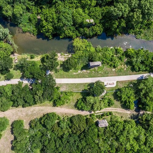
That wooded creek corridor is a big part of why the area retains a different visual character from many recently developed communities.
Why Does Brushy Creek Feel Different From Recently Developed Suburbs?
Now we get to the part that matters to someone shopping for a house today.
Because it grew differently.
There wasn't one development plan executed during one decade.
Brushy Creek is layered.
You can drive from a section developed in the 1970s...
to one built during the 1980s...
to another from the 1990s...
and then into later development.
That can mean differences in:
Home architecture
Lot sizes
Setbacks
Street layouts
Tree maturity
Sidewalks
HOA structures
Community amenities
And how closely a property interacts with parks or greenbelts.
The Trees Have Had Time to Grow
This sounds almost too obvious to mention.
But it's significant.
A tree planted beside a house in 1980 has had more than four decades to mature.
That changes how a street looks.
It changes shade.
It changes backyard privacy.
It changes how homes sit within the landscape.
And in some areas, large native trees predate the houses altogether.
You can't accelerate that process.
Recently developed communities may eventually develop similar tree cover.
Brushy Creek has simply had more time.
The Houses Don't All Look the Same
This is another side effect of building across several decades.
Older Brushy Creek sections can include traditional ranch-style homes, native limestone exteriors and floor plans common to the late 1970s and 1980s.
Other areas reflect the larger two-story designs popular in the 1990s.
Later sections brought different architecture again.
Even within one general home search, you can encounter dramatically different housing.
For some buyers, that's exactly the appeal.
They aren't choosing between twenty versions of essentially the same floor plan.
The Parks Feel Like Part of the Neighborhood
Another thing you'll notice:
Some Brushy Creek parks are surprisingly small.
And I mean that as a compliment.
Racine Woods Park.
Little Village Park.
Pepper Rock Park.
These aren't giant destination parks requiring a ten-minute drive.
They're pocket parks sitting right inside residential areas.
Then you also have larger facilities such as Cat Hollow Park, Sendero Springs Park and Community Park. Brushy Creek MUD's recreation planning intentionally includes both neighborhood parks and larger community facilities.
That layered park network mirrors the way Brushy Creek itself developed.
There's No Single Brushy Creek “Look”
And that's probably the biggest difference.
Ask someone to picture a recently developed master-planned community and they may immediately imagine a particular architectural style, entrance monument and streetscape.
Brushy Creek is harder to summarize.
Because Great Oaks doesn't look exactly like Cat Hollow.
Cat Hollow doesn't look exactly like Brushy Creek North.
Woods of Brushy Creek doesn't look exactly like Sendero Springs.
And that's because those communities didn't all arrive at the same time.
Brushy Creek's character is partly the result of decades passing between them.
One More Piece of History You Can Still See
If you want to connect the suburban Brushy Creek story back to the area's much older history, head east toward Old Town Round Rock.
The famous Round Rock still sits within Brushy Creek.
The limestone formation marked an important low-water crossing used by early travelers, and historic wagon ruts remain visible in the creek bed.
This photograph from Wikimedia Commons is free to reuse under a Creative Commons license and is only about 1.2 MB:
The Wikimedia image files of the Round Rock document the marker and explain that the Brushy Creek post office established in 1851 was renamed Round Rock in 1854.
It's a nice reminder that the suburban community's name isn't branding.
The creek came first.
So What Makes Brushy Creek...Brushy Creek?
It's not one thing.
It's the creek.
It's ranch land gradually becoming neighborhoods.
It's streets dating back to the 1970s sitting minutes from homes developed decades later.
It's a utility district that gradually became a major provider of parks, pools, trails and recreation.
It's mature trees.
It's neighborhood parks.
It's multiple HOAs instead of one massive association.
It's Round Rock addresses outside an incorporated city.
It's a regional trail following a waterway that has shaped the area for centuries.
And it's the fact that Brushy Creek wasn't created all at once.
It accumulated.
Layer by layer.
Neighborhood by neighborhood.
Decade by decade.
And I think that's exactly why it still feels different today.
Thinking About Moving to Brushy Creek?
Understanding the history won't tell you whether a particular house is the right one.
But it does explain why choosing where within Brushy Creek matters so much.
At Hoyden Homes, we help buyers look at the differences between those pockets—the age of the homes, lot characteristics, trails, parks, HOA structures, school boundaries, traffic patterns and how each section of Brushy Creek developed.
Because once you understand the history, the differences between the neighborhoods start making a whole lot more sense.
Check out this article next